Breaking News
Get 40% Off 0
Join +750K new investors every month who copy stock picks from billionaire's portfolios Sign Up Free
Close

Natural Gas Futures - Jul 24 (NGN4)

Create Alert
New!
Create Alert
Website
  • As an alert notification
  • To use this feature, make sure you are signed-in to your account
Mobile App
  • To use this feature, make sure you are signed-in to your account
  • Make sure you are signed-in with the same user profile

Condition

Frequency

Once
%

Frequency

Frequency

Delivery Method

Status

Add to/Remove from Watchlist Add to Watchlist
Add to Watchlist
Add Position

Position added successfully to:

Please name your holdings portfolio
 
2.886 -0.073    -2.47%
- Closed. Currency in USD ( Disclaimer )
Type:  Commodity
Group:  Energy
Unit:  1 Mmbtu
  • Prev. Close: 2.959
  • Open: 2.920
  • Day's Range: 2.870 - 3.000
Natural Gas 2.886 -0.073 -2.47%

Natural Gas Futures Contracts

 
In the table below you'll find the last, change, open, high, low and previous close for each Natural Gas Futures future contract. Click on the links column icons (Q C O) for quotes, charts, options and historical market data for each future contract - as well as the Natural Gas Futures Cash. (Price quotes for Natural Gas Futures are delayed by at least 10 minutes, as per exchange requirements).

 
Comment Guidelines

We encourage you to use comments to engage with other users, share your perspective and ask questions of authors and each other. However, in order to maintain the high level of discourse we’ve all come to value and expect, please keep the following criteria in mind:  

  •            Enrich the conversation, don’t trash it.

  •           Stay focused and on track. Only post material that’s relevant to the topic being discussed. 

  •           Be respectful. Even negative opinions can be framed positively and diplomatically. Avoid profanity, slander or personal attacks directed at an author or another user. Racism, sexism and other forms of discrimination will not be tolerated.

  • Use standard writing style. Include punctuation and upper and lower cases. Comments that are written in all caps and contain excessive use of symbols will be removed.
  • NOTE: Spam and/or promotional messages and comments containing links will be removed. Phone numbers, email addresses, links to personal or business websites, Skype/Telegram/WhatsApp etc. addresses (including links to groups) will also be removed; self-promotional material or business-related solicitations or PR (ie, contact me for signals/advice etc.), and/or any other comment that contains personal contact specifcs or advertising will be removed as well. In addition, any of the above-mentioned violations may result in suspension of your account.
  • Doxxing. We do not allow any sharing of private or personal contact or other information about any individual or organization. This will result in immediate suspension of the commentor and his or her account.
  • Don’t monopolize the conversation. We appreciate passion and conviction, but we also strongly believe in giving everyone a chance to air their point of view. Therefore, in addition to civil interaction, we expect commenters to offer their opinions succinctly and thoughtfully, but not so repeatedly that others are annoyed or offended. If we receive complaints about individuals who take over a thread or forum, we reserve the right to ban them from the site, without recourse.
  • Only English comments will be allowed.
  • Any comment you publish, together with your investing.com profile, will be public on investing.com and may be indexed and available through third party search engines, such as Google.

Perpetrators of spam or abuse will be deleted from the site and prohibited from future registration at Investing.com’s discretion.

Natural Gas Futures Discussions

Write your thoughts about Natural Gas Futures
 
Are you sure you want to delete this chart?
 
Post
Post also to:
 
Replace the attached chart with a new chart ?
1000
Your ability to comment is currently suspended due to negative user reports. Your status will be reviewed by our moderators.
Please wait a minute before you try to comment again.
Thanks for your comment. Please note that all comments are pending until approved by our moderators. It may therefore take some time before it appears on our website.
murari Ghaturkar
murari Ghaturkar 15 minutes ago
Saved. See Saved Items.
This comment has already been saved in your Saved Items
tomorrow nice chance to buy with strict SL 2.850....if SL get sell trend continues if sustain bellow 2.850
Bush Man
Bush Man 23 minutes ago
Saved. See Saved Items.
This comment has already been saved in your Saved Items
Leave John Balzarini alone. He provides more information in one post than many others will in all their posts.
Johnny Bravo Bravo
Johnny_Bravo 1 hour ago
Saved. See Saved Items.
This comment has already been saved in your Saved Items
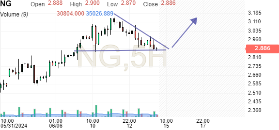
1718535199_84558.jpg
we have as well this kind of triangle ... GL Bears... you will need it ...
Sanjay Guru
Sanjay Guru 1 hour ago
Saved. See Saved Items.
This comment has already been saved in your Saved Items
Balarina we don't need you at this forum go flip some burgers with your dog tommy and AB MU you FOOL and biggest losser all time you ain't the pro stupid
Goodluck Badluck
Goodluck Badluck 1 hour ago
Saved. See Saved Items.
This comment has already been saved in your Saved Items
John besides of writing a big story , kindly say the theme and impact of that story on NG price. Thanks
John Balzarini
John Balzarini 1 hour ago
Saved. See Saved Items.
This comment has already been saved in your Saved Items
URGENT - WEATHER MESSAGE National Weather Service Midland/Odessa TX 1228 AM MDT Sun Jun 16 2024 HEAT ADVISORY REMAINS IN EFFECT FROM NOON MDT /1 PM CDT/ TODAY TO 8 PM MDT /9 PM CDT/ THIS EVENING... temperatures up to 104 expected. On the Culberson and Eddy County Plains, as well as Pecos and Winkler Counties, temperatures up to 109 expected. On the Reeves County Plains, and in Loving and Ward Counties, the Presidio Valley, and Lower Brewster County, temperatures up to 114 expected. * WHERE...Portions of southeast New Mexico and southwest and western Texas. * WHEN...From noon MDT /1 PM CDT/ today to 8 PM MDT /9 PM CDT/ this evening.
Sanjay Guru
Sanjay Guru 1 hour ago
Saved. See Saved Items.
This comment has already been saved in your Saved Items
Balarina you stupid storyteller go f..k yourself and AB MU you Fool
Cyrus Cyrus
Cyrus Cyrus 2 hours ago
Saved. See Saved Items.
This comment has already been saved in your Saved Items
I wanna read another shy peson here to save their words
John Balzarini
John Balzarini 2 hours ago
Saved. See Saved Items.
This comment has already been saved in your Saved Items
URGENT - WEATHER MESSAGE National Weather Service Wilmington OHIO 324 AM EDT Sun Jun 16 2024 EXCESSIVE HEAT WATCH IN EFFECT FROM MONDAY AFTERNOON THROUGH FRIDAY EVENING... * WHAT...Prolonged period of dangerously hot conditions with heat index values around 100 possible. * WHERE...Portions of east central and southeast Indiana and central, south central, southwest, and west central Ohio. * WHEN...From Monday afternoon through Friday evening. * IMPACTS...Heat related illnesses increase significantly during extreme heat and high humidity events, particularly for those working or participating in outdoor activities.
Cyrus Cyrus
Cyrus Cyrus 2 hours ago
Saved. See Saved Items.
This comment has already been saved in your Saved Items
home here?
John Balzarini
John Balzarini 2 hours ago
Saved. See Saved Items.
This comment has already been saved in your Saved Items
Special Weather Statement National Weather Service PADUCAH KY 348 AM CDT Sun Jun 16 2024 ELEVATED HEAT INDEX VALUES TODAY... The combination of very warm temperatures along with increasing relative humidity today will result in uncomfortably hot temperatures across the region. Heat index values are expected to range between 100 and 105 degrees this afternoon into the early evening hours. Western Kentuky If working outside today, be sure to drink plenty of water, wear loose-fitting and light-colored clothing, and take frequent breaks in air-conditioned locations. Be sure to check on those most vulnerable to heat, including children and the elderly, provide shade and fresh water for outdoor pets and livestock, and check the backseat of your vehicle when transporting children.
John Balzarini
John Balzarini 2 hours ago
Saved. See Saved Items.
This comment has already been saved in your Saved Items
URGENT - WEATHER MESSAGE National Weather Service Mount Holly NJ 347 AM EDT Sun Jun 16 2024 HEAT ADVISORY IN EFFECT FROM 10 AM TO 10 PM EDT TUESDAY... * WHAT...Heat index values up to 102 expected. * WHERE...New Castle Delaware, the greater Philadelphia metro area, and portions central New Jersey along the I95 corridor. * WHEN...From 10 AM to 10 PM EDT Tuesday.
 
Are you sure you want to delete this chart?
 
Post
 
Replace the attached chart with a new chart ?
1000
Your ability to comment is currently suspended due to negative user reports. Your status will be reviewed by our moderators.
Please wait a minute before you try to comment again.
Add Chart to Comment
Confirm Block

Are you sure you want to block %USER_NAME%?

By doing so, you and %USER_NAME% will not be able to see any of each other's Investing.com's posts.

%USER_NAME% was successfully added to your Block List

Since you’ve just unblocked this person, you must wait 48 hours before renewing the block.

Report this comment

I feel that this comment is:

Comment flagged

Thank You!

Your report has been sent to our moderators for review

Continue with Google
or
Sign up with Email